Delhi Metro Map
Interactive Delhi Metro Network Map
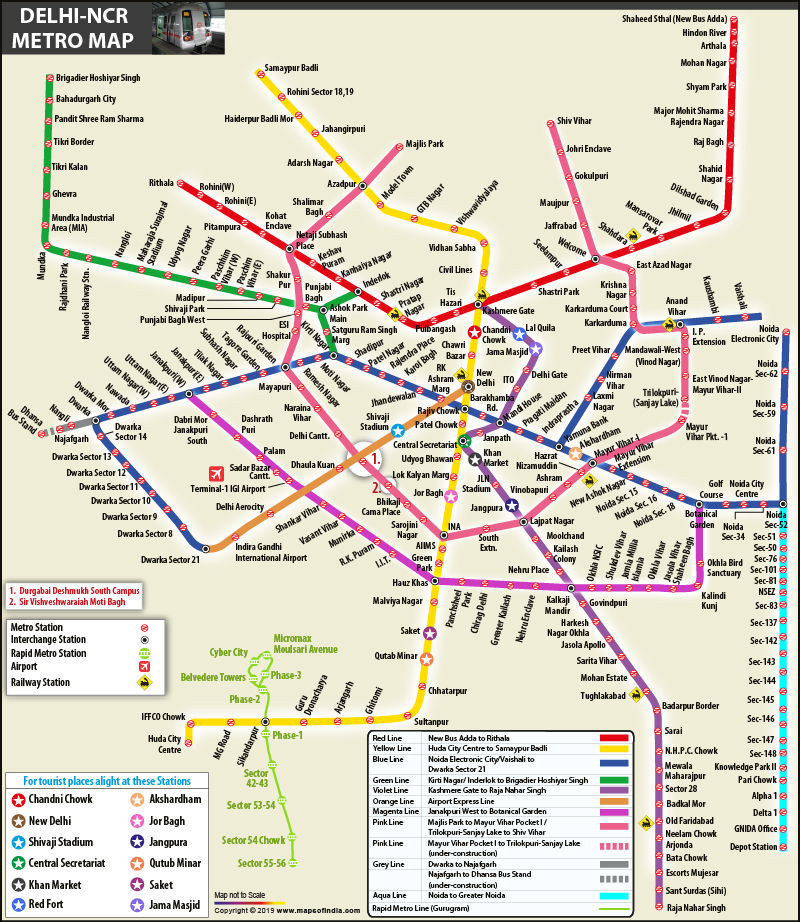
Delhi Metro Network Information
The Delhi Metro is a mass rapid transit system serving Delhi and its satellite cities of Ghaziabad, Faridabad, Gurugram, Noida, Bahadurgarh and Ballabhgarh in the National Capital Region of India. It is the largest and busiest metro in India, and second oldest after the Kolkata Metro.
Delhi Metro Lines
The Delhi Metro network consists of 10 color-coded lines:
- Red Line: Connects Rithala to Shaheed Sthal (New Bus Adda)
- Yellow Line: Connects Samaypur Badli to Millennium City Centre Gurugram
- Blue Line: Connects Dwarka Sector 21 to Noida Electronic City/Vaishali
- Green Line: Connects Brigadier Hoshiar Singh to Inderlok/Kirti Nagar
- Violet Line: Connects Kashmere Gate to Raja Nahar Singh (Ballabhgarh)
- Pink Line: Connects Majlis Park to Shiv Vihar
- Magenta Line: Connects Botanical Garden to Janakpuri West
- Grey Line: Connects Dwarka to Dhansa Bus Stand
- Orange Line: Airport Express Line connecting New Delhi Railway Station to Dwarka Sector 21
- Rapid Metro: Connects Sector 55–56 to Phase 3 in Gurugram
Major Interchange Stations
The Delhi Metro network has several interchange stations that allow passengers to switch between different lines:
- Rajiv Chowk: Yellow Line and Blue Line
- Kashmere Gate: Red Line, Yellow Line, and Violet Line
- Central Secretariat: Yellow Line and Violet Line
- Mandi House: Blue Line and Violet Line
- Inderlok: Red Line and Green Line
- Welcome: Red Line and Pink Line
- Hauz Khas: Yellow Line and Magenta Line
- Botanical Garden: Blue Line and Magenta Line
Using the Delhi Metro Map
Our interactive Delhi Metro map allows you to:
- Zoom in and out to see details
- View all metro lines with their distinct colors
- Identify interchange stations
- Download a PDF version for offline use
Use our Route Finder to plan your journey between any two stations on the Delhi Metro network.